 |
| Bundles of Eastern White Pine needles surround next-spring's bud at the tip of a twig. © Dave Spier [1-5X macro lens at 2X on full-frame sensor + twin macro flash]
Tree of Peace
© Dave Spier
To the Iroquois, the Eastern White Pine (Pinus strobus) was known as the "Tree of Peace" and it symbolized the Great Law of Peace that united five tribes into one confederacy or league, thus ending decades, and probably centuries, of conflict between these groups. The date is unknown, but precedes white settlement of Upstate New York. Estimates range from 1100 A.D. to somewhere in the 1500's.
The Iroquois called themselves Haudenosaunee, or People of the Longhouse. The name "Iroquois" is a French transliteration from derogatory terms used by the Hurons (in Canada) and Algonquins (from New England to the mid-Atlantic), both enemies of the Haudenosaunee.
All pines have leaves that grow in bundles of two, three or five needles bound together by a sheath where they emerge from the twig. White pines have clumps of five needles, and to the Iroquois Confederacy, these symbolized the original Five Nations: Seneca, Cayuga, Onondaga, Oneida and Mohawk. What is now the Adirondacks was divided by the Oneidas to the west and the Mohawks to the east. The Tuscaroras, after being displaced from North Carolina, were eventually admitted to the Confederacy and merged with the Onondagas and Oneidas in central New York.
White pine needles, generally three inches long, are thin, soft and flexible. It's easy to "shake hands" with a white pine (whereas many other pines have stiff, prickly needles). The name of this species comes from fine, whitish stripes along the length of the green needles, but you'll probably need a magnifying glass to see them clearly. During their second year of growth, the needles turn yellow and fall.
Cones are generally six inches long and easy to handle. Many pines have shorter, compact cones with prickles at the tips of their scales.
White pines can reach great age and size. Many old pines that survived logging in the Adirondacks are over 300 years old. One near Syracuse was dated at 458 years. Mature trees easily tower over their deciduous compatriots. In pre-colonial America, specimens were reported at 230 feet high and these were later reserved by the king to become ship masts in the British Royal Navy. The current Eastern White Pine record holder in the Great Smokies reaches 188 feet. (It was 207 feet high before a hurricane took off the top.)
Corrections and questions may be sent to northeastnaturalist@yahoo.com
|
Wednesday, December 28, 2011
Tree of Peace
Friday, December 16, 2011
Christmas Bird Count
 |
| Two Common Loons were seen on Bolton Landing’s 2010-2011 CBC. One was seen on the Old Forge count, which is unusual for the time of year. This winter-plumage COLO was photographed in early January. (© Dave Spier) |
Christmas Bird Count -- © Dave Spier
It's time again for the annual Christmas Bird Count (CBC). Not that it actually occurs on Christmas Day anymore, but now it can be any day from December 14 through January 5 (i.e., 11 days before and after Christmas). The CBC was invented in 1900 as an alternative to the Christmas side hunt in which teams of men went out and shot everything in sight. The biggest pile of feathered and furred animals won. More of the history can be found on the Audubon website. You also can follow links to individual counts and past results.
The Christmas Bird Count is an annual citizen-science project now in its 112th year. Such a long-term perspective allows ornithologists to monitor population trends - some good, some bad. Please consider joining one of the five local counts inside the Adirondack Blue Line [note: the Ferrisburg, VT CBC circle extends west across Lake Champlain into the Adirondacks], or one of the many peripheral counts in New York if you can make it. If you lack confidence, it's often possible to be paired with an experienced observer.
Counts inside the Blue Line:
Bolton Landing - code NYBL
Elizabethtown - code NYEZ (Sun., Dec. 18)
[Ferrisburg, VT - code VTFE (Sat., Dec. 17)]
[Ferrisburg, VT - code VTFE (Sat., Dec. 17)]
Old Forge - code NYOF
Saranac Lake - code NYSL (Sun., Jan. 1)
Closest peripheral counts:
Fort Plain (Fri., Dec. 30)
Massena-Cornwall - code NYMC (Tue., Dec. 27)
Massena-Cornwall - code NYMC (Tue., Dec. 27)
Plattsburgh - code NYPL (Sun., Dec. 18)
Saratoga Spa - code NYSS
Thousand Islands - code ONTI
Watertown - code NYWA
Wilson-Lake Plains - code NYWL
Counts are conducted in predetermined 15-mile diameter circles during a 24-hour period (midnight to midnight). In fact you can start at midnight by listening for owls! (but most people wait till at least dawn). For easier coverage, the circles are divided into sectors (sections) and participants can bird as long (or short) as desired, but time and any mileage must be recorded. To cover administrative costs and keep the count going there is a $5 participation fee for anyone over 18.
If you live within the 15-mile diameter circle of a particular count, you also can choose to stay home and just watch your feeders and count all the yard-birds including any fly-overs. All species count. Keep track of the maximum number of individual birds of each species seen and the length of time you spend watching for birds. Contact the compiler in advance so he/she knows to expect your data; final results can be phoned in the evening.
(Most) counts are followed by a compilation dinner or meeting. For example, the E-town post-count meeting will be at the Deers Head Inn Restaurant (7552 Court Street) in Elizabethtown, NY around 5:00 pm. Contact Charlotte Demers in advance. For the Massena-Cornwall CBC, contact Eileen Wheeler. For Fort Plain, it's Tom Salo. For Saranac Lake, Larry Master.
Regarding this blog, contact me at northeastnaturalist@yahoo.com and visit our parallel blog at http://northeastnaturalist.blogspot.com/
Sunday, December 11, 2011
Crossbills
 |
| Male White-winged Crossbill in ornamental Douglas Fir -- © Dave Spier |
Crossbills -- © Dave Spier
White-winged Crossbills, an irruptive species in winter, are frequently reported on NNY Birds. Their traditional diet of Canadian spruce seeds sometimes runs low and once exhausted, the birds head south in higher numbers. The birds' small, thin bills, which are crossed at the tips, allow them to specialize on the small, soft cones of Spruces (White, Black, and Red), larch, Eastern Hemlock, Northern White Cedar and Red Cedar. The White Pine, unlike other eastern pines, has soft cones that can be utilized by crossbills. They also use Douglas Fir and Blue Spruce, introduced species in the east.
White-winged Crossbills (Loxia leucoptera) are medium-sized finches with a year-round range from Alaska eastward through the boreal forest zone to the Canadian Maritimes. There’s a fair number of breeding reports from around the Adirondacks with a concentration of confirmed sightings in northern Herkimer County and adjacent Hamilton County.
In the winter, they migrate erratically into the northern states with sporadic reports from the central states. Adult males are dull red with black wings and two prominent white wingbars. Females are yellowish gray with similar wings. Juveniles are heavily streaked and somewhat resemble Pine Siskins, another winter visitor. In Europe the white-winged is called the Two-barred Crossbill.
Another species, the Red Crossbill (Loxia curvirostra) is similar, but has a heavier bill and lacks the white wing bars. [In rare cases, a variant of the first-year male can display weak wingbars.] There are nine recognized "types" (similar to subspecies) of Red Crossbills and some of these may be evolving into separate species. The specially adapted beaks are pointed and crossed at the tips, but the size and exact structure varies among the different types depending on the species of cone they are best adapted to. The heavier bill allows Red Crossbills to pry out seeds from heavy pine cones in addition to spruce and fir. An individual crossbill can extract and eat 3000 conifer seeds in one day, which probably explains why they keep moving in search of new food sources.
Thursday, December 8, 2011
Pine Siskins

Siskins -- © Dave Spier
Pine Siskins (Spinus pinus) are heavily streaked with yellow feather edges on the wings and yellow patches on the inner tail sides. The amount of yellow varies with less on young birds and more on adult males. Since this gregarious bird tends to travel in flocks, at least some members will show varying amounts of yellow. There are also two buffy wing bars. Siskins also hang with goldfinches; both are members of the same family and about the same size and once shared the same genus (Carduelis). Female House Finches are similar, but larger with lower-contrast streaking. Siskins also resemble redpolls, another finch, but redpolls have a red cap. Siskins have notched tail ends, but so do female Purple Finches which have high-contrast streaking, a plumper build and heavier bills. If you’re having trouble, the best bet is to take a photo and send it to northeastnaturalist@yahoo.com
When winter food supplies are short in their Canadian boreal homeland, siskins wander south, showing up first in similar forested habitats in the Adirondacks where significant flocks have been reported throughout October and November. (Details can be found on the Google group, Northern New York Birds. There's also a link in the right sidebar.) Recent reports [Nov. 29] have come from Joan Collins at Sabattis Bog, Little Tupper Lake, several locations on Rt. 28N including flocks totalling 200 in Minerva, and the Roosevelt Truck Trail with 150 siskins. Joan's more recent posts [Dec. 4] from Horseshoe Lake and Low's Ridge-Upper Dam Trail have reported smaller numbers in these locations.
Pine Siskins are one of several kinds of birds referred to as “irruptive species,” meaning they can show up unexpectedly anywhere in the lower 48, and the pattern changes from year to year. A few birds may linger into the spring and act as though they will nest locally, which they do in New York State. The heaviest concentration of nesting records occurs in three clumps from roughly Norwich to Saranac Lake and Lake Placid.
Siskins are seed eaters. They prefer conifers [spruce, pine, cedar and hemlock], but also eat seeds from deciduous trees [especially birch], shrubs [particularly alder], flowers [weeds] and grasses. They readily come to thistle-seed feeders, sometimes in large flocks, but also eat sunflower seeds – basically the same diet as goldfinches. By the way, goldfinches and siskins can feed upside down. Special feeders are made with the seed holes below the perches. In the case of siskins the skill is useful in extracting seeds from conifer cones.
Questions, comments and corrections are welcomed. Some of my other nature columns [more relevant to the Adirondack perimeter and New York lowlands] can be found on http://northeastnaturalist.blogspot.com
Thursday, December 1, 2011
Silver Lake Bog -- © Dave Spier
 |
| Tamarack and spruce beside the Bog Trail (early October) - © Dave Spier |
I know it simply as Silver Lake Bog, but in the 2011 annual report from The Nature Conservancy’s Adirondack Chapter, it’s listed as Silver Lake Bog Nature Preserve and on eBird it’s “Silver Lake Camp Preserve” referring to the Silver Lake Camp for Girls which operated from 1911 to 1972 before 61 acres were donated to the recently-created Adirondack Nature Conservancy in the mid-70’s to become one of its earliest preserves. The original size has grown to 98 acres now. You can take a virtual tour via a slide show on the TNC website.
The bog is in the southwestern corner of Clinton County on the old Hawkeye Road off Union Falls Road. From Hawkeye travel west about 1.5 miles and turn south on Old Hawkeye Road. Parking is about a half mile down the dirt road. Exact directions [with an interactive Google map] are on the Conservancy’s website. In DeLorme's N.Y. Gazetteer, Silver Lake's north shore is bottom center on page 102, but the Old Hawkeye Road is too short to be labeled.
 |
| Boardwalk across Silver Lake Bog (early October) - © Dave Spier |
The highlight of the preserve is a roughly half-mile boardwalk west across the wetlands. The depression supports a Northern White Cedar swamp and Black Spruce-Tamarack bog. A trail guide describes plants and animals at 15 stops along the Bog Walk.
At the far end of the bog walk, the trail rises into an upland forest of northern hardwoods and hemlock and then turns south on its way to a pine bluff overlooking Silver Lake. The flip side of the trail guide describes eight stops along this Bluff Trail.
 |
| Eastern Hemlock roots beside Bluff Trail (early October) - © Dave Spier |
The preserve seems larger than its size because it’s generally narrow and L-shaped. Total trail length is 1.25 miles one way to the lake.
 |
| Pine Bluff overlooking Silver Lake in October (super-wide angle lens) - © Dave Spier |
Birds at Silver Lake Bog
The eBird bar chart for Silver Lake Camp Preserve lists 70 species so far, but the data is very incomplete, especially during the winter months. (There’s no data for November and January and none for the first three weeks of December. For all of February there is only one week covered and that has only 2 bird species.) If you’re in that area, please stop and record any and all birds seen or heard, even if they’re just from the beginning of the trail near the road, and submit to eBird. At least it will be a start toward filling in the gaps. Another hole in the data is the lake itself; there are no eBird records for waterfowl – zero – not counting Common Loon reported in May and July at this location.
For another perspective on the bird life in the general vicinity, Silver Lake Bog is in N.Y.S. Breeding Bird Atlas block 5892A. A block is roughly nine square miles and this one includes the western 3/4ths of Silver Lake, the eastern part of Union Falls Pond and the west end of Taylor Pond. There were 88 species (including Wood Duck, Mallard and Common Merganser) reported in 2000-2005 during the nesting seasons. Of the Anatidae waterfowl, only Mallard is actually a confirmed breeder in 5892A. There were 30 other species also confirmed. [To see the complete list, click the link above, type in 5892A and click "submit."]
Send corrections and comments to northeastnaturalist@yahoo.com
A few more Silver Lake Bog (early October) photos
 |
| Prime ingredient of a bog is sphagnum moss [there are
numerous species]; Silver Lake Bog - © Dave Spier
|
 |
| The bog is supported by a high water table; Silver Lake Bog - © Dave Spier |
 |
| Tiny Marasmius mushrooms (October) - © Dave Spier |
 |
| Carnivorous Pitcher-plant, Sarracenia purpurea - © Dave Spier |
 |
| Puffballs, likely Lycoperdon sp. (possibly perlatum) in October;
sorry, I only stopped long enough to photograph them - © Dave Spier
|
Saturday, November 19, 2011
Boreal Chickadees -- © Dave Spier
 |
| Boreal Chickadee in a White Pine by Dave Spier [scanned from a old slide] see the links at the end of this blog post for great photos by other photographers |
Judging by recent reports on Northern New York Birds, there's no shortage of Boreal Chickadees (Poecile hudsonica) in the Adirondacks. If you're looking for a specific location, try the Roosevelt Truck Trail off Route 28N in Minerva. The trail runs north from the old, narrow sideroad 1.6 miles north of the Boreas River bridge; details are in the ADK guidebook. Birding guide, Joan Collins, said, "I had a beautiful walk on the Roosevelt Truck Trail [November 16]. I don't recall ever finding as many Boreal Chickadees on one walk. Views of the Boreal Chickadees were terrific throughout the hike.”
They're also likely to be encountered in northern New England, much of Alaska and certainly in their trans-Canada strongholds from coast to coast south of the tree line. For an eBird range map, look under View and Explore Data, and then zoom in for finer detail. At the highest resolutions you’ll find individual locations and checklists. If you continue north on the map through Canada, you’ll find the data is incomplete, so if you’re ever up that way, please submit your complete checklists to eBird and help fill in the gaps.
Not surprisingly, almost all of the 2000-2005 Breeding Bird Atlas records for Boreal Chickadees are clustered in the Adirondacks. The two exceptions are on the Tug Hill between Lake Ontario and the Adirondacks.
The Boreal's preferred habit is dense northern (boreal) coniferous forests, so whenever they move in search of winter food, they're usually found in a similar environment, often in association with their close relatives, the Black-capped Chickadees (Poecile atricapilla). At a distance the two species can be separated by song, with the Boreal's being a slower, raspier version of the familiar "chicka-dee-dee-dee," but more like "che-day-day" at a lower pitch.
All chickadees come to suet and sunflower seed feeders. If you have conifers (spruce, pine, firs or hemlock) in your yard or nearby, pay some extra attention to any chickadees coming to your feeder. Watch for any with a brown cap, gray sides of the neck behind the white face, and light-brown flanks. (All chickadees have the black bib and underthroat.) If you see one [or more], please report it [them] to eBird, or email me at northeastnaturalist@yahoo.com
For great photos of Boreal Chickadees, please visit Jeff Nadler's website and Larry Master Conservation Photography
Saturday, November 12, 2011
MOOSE -- © Dave Spier
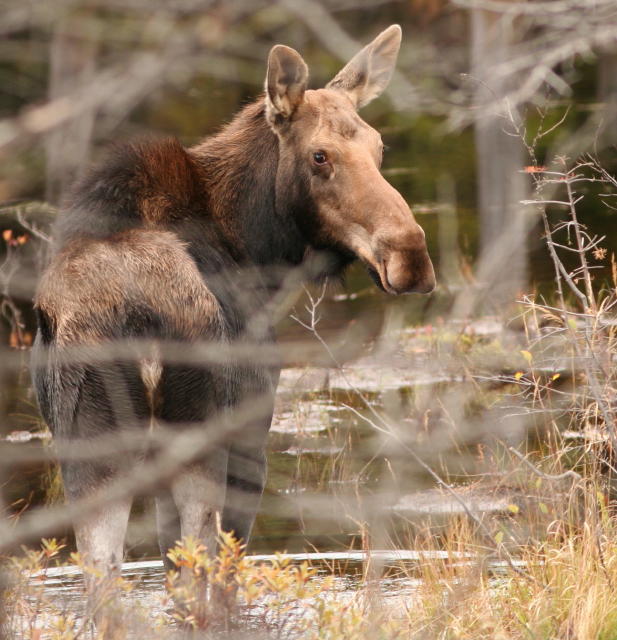 |
| Female Moose (October) -- © Dave Spier |
In an issue of D.E.C. Field Notes (Nov. 4), there are links to a Moose fact sheet and a gallery of NY Moose photos from various counties (mostly Hamilton and Essex, plus Warren, Herkimer, St. Lawrence, Oneida, Lewis, Rensselaer, and Saratoga). A video about tagging and tracking Moose in NY was not working. North Country Public Radio featured moose as a Photo of the Day.
I have no secret hotspots for finding Moose in the Adirondacks. The last estimates I saw of Moose numbers in New York ranged up to 800, based on statistical analysis of sightings, vehicle collisions and reports from hunters. (Moose are protected in New York, so these were people hunting deer, bear, ducks, etc.) Average that population across the region and you get 7500 acres per Moose. Ideal habitat is a mix of forests with both deciduous and coniferous trees for shelter and browse, plus small clearcuts for regeneration of additional browse plus wetlands for aquatic vegetation eaten in the summer. Moose are therefore unevenly spread across the Adirondacks and some of the population is located in the Taconic Highlands.
Send corrections and comments to northeastnaturalist@yahoo.com
Sunday, November 6, 2011
Autumn Gold -- © Dave Spier

 |
| October snow on larch (tamarack) branches before the needles fall - note all the cones. Natural Bridge, NY - © Dave Spier |
Larches are related directly to pines and less directly to spruce, hemlock and Balsam Fir. All of these conifers produce so-called naked seeds. The Greek word for naked is gymnos, and yes, it's the original root of the word gymnasium. Combine this with sperma, the Greek word for seed or germ, and you get the botanical classification gymnosperm. (Other members of this group include yews, redwoods, cycads, cedars, cypress and the Ginkgo.) By contrast, angiosperms, or flowering plants, are evolutionarily more modern. Their seeds are enclosed by the ovary.
The native Eastern [American] Larch (Larix laricina) grows in bogs and boreal (northern coniferous) forests wherever it can get enough sunlight. It is one of the pioneer tree species but cannot grow in the shade of other trees. Overall, larch is now more abundant than it was before the logging of the late 1800's and early 1900's opened the forest canopy and allowed more light to reach the ground. (The Boreal Life Trail at Paul Smiths is a good place to see larches in their natural habitat.) Altitude is little hindrance to larches; they grow at 4620' on Haystack. At lower elevations, larches can reach heights of 60 to 80 feet, but still die out as mature forests reclaim the land and close the canopy, thereby preventing rejuvenation from seedlings.
European Larch (Larix decidua) is widely planted as an ornamental and for timber harvesting. Pure stands of tall larches are very likely this species.
Fortunately, larches are still commonly called Tamaracks (Algonquian). "Larch Lodge" just doesn't have the ring of "Tamarack Lodge."

Tuesday, October 25, 2011
artistic accident
Sometimes I have what I call an "artistic accident," a.k.a. "accidental art." I unintentionally bumped the shutter release; in fact, I didn't even know it happened till I downloaded the photos.
 |
| "Artistic accident" on the Brewster Peninsula trail, Lake Placid - © Dave Spier |
Russula mushrooms -- © Dave Spier
 |
| Russula mushrooms at Wilmington Notch in early October -- © Dave Spier |
For a change of pace, here’s an attractive but potentially poisonous mushroom from earlier this month. It’s one of the Russula’s, a genus with a handful of species, several of which have red caps. I’m pretty sure it’s Russula emetica, a poisonous species. A check of the gills underneath shows that they are attached to the stalk, not free [attached only to the cap and not the stem at the inner gill edge]. To give you some idea of the difficulty in identifying mushrooms, I first referred to Mushrooms of Ontario* which lists emetica as having "nearly free" gills. That would have made it more likely they’re Russula paludosa, a slightly larger species with supposedly attached [adnate] gills according to the book. Next I checked Peterson’s Mushrooms** which describes emetica gills as "adnate (broadly attached to stalk apex)."
As for cap size, the ones I found are in the overlap zone, about three inches across (although I didn’t have a ruler with me).
Alan Bessette, in his book Mushrooms of the Adirondacks,*** lists 13 species of Russula’s, at least of them five of them red, orange-red or wine-red in color. As with many similar-looking groups of mushrooms, a microscope and spore guide are needed for accurate identification. Since edible and poisonous mushrooms can be near look-alikes, it’s best to avoid eating most wild mushrooms.
In the Audubon Pocket Guide,**** the Russula emetica (identical to the ones I photographed) is listed as the "Sickener" with a "hot, acrid taste." Other guides describe it as bitter to sharp pepper. Sorry, I did not taste the Russula's in Wilmington Notch.
The habitat is listed as conifers or mixed woods (a good match to the Wilmington Notch location), but several books also mention bogs and sphagnum moss (common in bogs).
Corrections and comments may be sent to northeastnaturalist@yahoo.com
*Mushrooms of Ontario and Eastern Canada, Lone Pine Publishing, © 1999 George Barron
**Mushrooms, Peterson Field Guides, Houghton Mifflin, © 1987 by Kent & Vera McKnight
***Mushrooms of the Adirondacks, North Country Books, Utica, © 1988 by Alan Bessette
****Familiar Mushrooms North America, The Audubon Society Pocket Guides, Alfred A. Knopf, © 1990
Monday, October 24, 2011
Grass River Waterfalls
 |
| Basford Falls photo © Donna Mason-Spier |
Grass River - Tooley Pond Tract Waterfalls - © Dave Spier
The blog description promised Adirondack geology. This is offered as a down payment.
The South Branch of the Grass River descends the Adirondack dome as it crosses St. Lawrence County and merges with other branches on their way to Massena where the Grass nearly converges with the Raquette River before joining the St. Lawrence River. A particularly accessible section of the South Branch along Tooley Pond Road contains a number of attractive waterfalls.
For geology nuts, the exposed bedrock between DeGrasse and upstream at Clarksboro and beyond is hornblende-biotite granitic gneiss [designated as hbg on the Adirondack Geologic Map prepared by the N.Y.S. Museum]. Like much of the Adirondacks, it is metamorphic, changed by heat and pressure during the Grenville collision roughly 1100 million years ago. Hornblende and biotite mica are dark minerals that give the gneiss a streaky or banded appearance in cross-section. Granitic gneiss contains some quartz in addition to the light-colored feldspar minerals. The Adirondacks are a southeastern extension of the Grenville Province, the eastern portion of the Canadian Shield.
For waterfall nuts, Tooley Road can be accessed from Route 3 just west of Cranberry Lake and going north through Cook Corners, but we sometimes prefer going around and taking County Road 27 from Fine to DeGrasse, turning right toward Clare and then taking Tooley Pond Road from its west end.
At 1.4 miles, there’s a woodland trail to Basford Falls. It’s maybe a half-mile? walk with a descent to some very old white pines as you reach the falls. The following Basford Falls photos are © Donna Mason-Spier:


 |
| top of Basford Falls - photo © Donna Mason-Spier |
At 2.0 miles, there’s a parking area and information kiosk for Sinclair Falls, but save yourself a few steps by driving west on Lake George Road and parking just before the bridge. Sinclair is more of a long, curving slide than steep drop, but impressive none-the-less. The following Sinclair Falls photos are © Donna Mason-Spier:


At 3.3 miles, the road passes Stewart Rapids which can be seen from the shoulder. Continuing to 3.5 miles, the trail to Bulkhead Falls is now overgrown and nearly impossible to find, so I’ll save that for another time when I can scan some old slides.
At 6.1 miles, stop for Rainbow Falls. There’s an old clearing set off by boulders and a trail along an old road for maybe a quarter mile to a footbridge over a side channel. Once on the island there are several trails, but be very careful when you reach the cliff with overlooks; there are no railings and wet footing can be slippery. The following Rainbow Falls photos are © Donna Mason-Spier:
 |
| from the footbridge to Rainbow Falls - photo © Donna Mason-Spier |


Contact us at northeastnaturalist@yahoo.com and visit a parallel blog at http://northeastnaturalist.blogspot.com/
Saturday, October 22, 2011

The Northern Harrier, once known as the "marsh hawk," is what I call an Adirondack peripheral species more common around the edges. It's a slender and buoyant hawk with a somewhat owl-like face. The hawk's long wings and tail are designed for life in the open. If it tips toward you, look for the distinctive white rump patch. When soaring, the wings are held in a shallow V (called a dihedral) with the tail fanned. At low altitudes, the tail is usually closed and the wings held flat to the sides. In a steep glide, the wings are sharply bent and swept back like a fighter jet.
Mostly it flies low over the grasslands and the marshes while it looks for small mammals, especially Meadow Voles (also called field mice) which are caught with a sudden pounce. Sometimes this large bird's flight drifts back and forth, then stops momentarily to hover before pouncing. In warm weather it hunts snakes, frogs and insects. When all else fails, carrion is eaten.
 |
| Male Northern Harrier eating prey (probably a vole) in a field -- © Dave Spier |
In the winter, harriers hang around with Short-eared Owls and share the same fallow, grassy fields where mice have had time for a population explosion. Both species will use fence posts for hunting perches as they listen for prey. Though unrelated species, the facial disks of both harriers and owls seem to help focus sounds on the ears.
The harrier's Latin name, Circus cyaneus, refers to its circling flight and the supposedly blue plumage of the males. The color is actually gray, but that's only half the story because females and juveniles are brown, an unusual disparity for raptors. The bodies of juveniles are orangish underneath. The name harrier is Old English for "harassing with hostile attacks." Other colloquial names include blue hawk, mouse hawk and white-rumped hawk. Males are smaller and more agile and catch smaller prey, including birds.
 |
| Female Northern Harrier (note the white rump) over a marsh -- © Dave Spier |
Harriers breed from Alaska across Canada to the Maritimes and south into the United States as far as a line from California to Pennsylvania. The 2000-2005 N.Y.S. Breeding Bird Atlas contains 32 breeding records for harriers in the core Adirondack region (not counting the Champlain lowlands). Of these, six are confirmed, three more are probable and 26 are possible. There is a heavy concentration of harrier breeding records in the St. Lawrence lowlands of northern Jefferson County. In fact, the Adirondacks are surrounded by numerous records including the Champlain area. (Click for a map)
Most harriers head south for the winter and return in the spring, but a number of birds, likely adults with good hunting skills, will stay in the north (see the previous post about the Fort Edward Grasslands Important Bird Area).
[bold blue type indicates a link] Contact me at northeastnaturalist@yahoo.com
 |
| Male Northern Harrier tearing apart prey in a field -- © Dave Spier |
Raptor Survey Volunteers Needed for Fort Edward IBA
 |
| Northern Harrier(male) -- © Dave Spier |
From the Oct. 21 issue of Field Notes...
"Be a part of DEC's continued effort to monitor the movement and habitat use of raptors like the northern harrier, short eared owl, red-tailed hawk, and others this winter. Currently, volunteers are needed to help survey these birds of prey at the Fort Edward Important Bird Area in Washington County, NY. You can volunteer to participate in one or more surveys conducted once a month from December through March. If interested in participating, or for more information, please contact Theresa Swenson at tgswenso@gw.dec.state.ny.us by December 1."
The Fort Edward Grasslands IBA in the Hudson River Valley is 13,000 acres east of Fort Edward and south of Route 197. (This is southeast of Glens Falls outside the Blue Line.) [bold blue type indicates a link]
 |
| Short-eared Owl -- © Dave Spier |
Friday, October 21, 2011
Winterberry -- © Dave Spier
 |
| Winterberry at Nick's Lake before the leaves turned color and fell -- © Dave Spier |
The Winterberry's genus, Ilex, is the Latin name for the Mediterranean holly oak, another non-relative, and the species name verticillata means whorled, probably referring to the way the berries hug the twigs. The holly used at Christmas, Ilex aquifolium, is a European import with spiny-edged, evergreen leaves. "Aquifolium," meaning pointed leaves, was the Latin name for holly.
 |
| Another view of Winterberry (holly) at Nick's Lake, Old Forge -- © Dave Spier |
Winterberry occurs naturally throughout the eastern United States where it grows in swampy thickets, peat bogs, and lowland roadsides. It often marks wet acidic soils. In the spring, small yellowish-green to white flowers grow in the leaf axils (where the leaf stems attach to the twigs). The male flowers grow in crowded clusters on separate plants. The alternate leaves, with their blunt points and toothed margins, fully appear after the flowers so as to not interfere with pollination by bees and other insects. The red fruits appear in September and persist into winter, assuming the birds do not eat all of them right away.
Winterberry makes a nice addition to any landscape scheme and adds a showy touch of color to an otherwise dull December day. This shrub does well in moist, acidic soils with full sun or partial shade. The trick is to have at least one male plant to pollinate up to nine female bushes in the vicinity. The added benefit of this native is more food for robins, bluebirds, and waxwings before they head south.
Does winterberry grow near your home and what animals eat the fruits? Contact me at northeastnaturalist@yahoo.com
 |
| Another view of Winterberry (holly) at Nick's Lake, Old Forge -- © Dave Spier |
Subscribe to:
Posts (Atom)